Explosive contamination diagnostics use geophysical tools to inspect the subsoil and identify anomalies that could be unexploded munitions or explosive remnants of war.
This phase is carried out by geophysicists specialized in this operation, in constant connection with explosives clearance operations in order to continually improve the analysis and selection of potential targets.
This phase is carried out by geophysicists specialized in this operation, in constant connection with explosives clearance operations in order to continually improve the analysis and selection of potential targets.
DEMINETEC performs and commits:
Explosive contamination diagnostic operations.
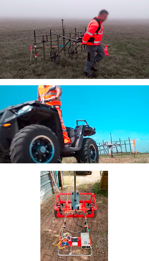
Geophysical diagnostics of explosive contaminationExplosive contamination diagnostics aim to find all anomalies present in the subsoil that are likely to be unexploded ordnances (UXO) or explosive remnants of war (ERW). There are essentially 2 types of means used by DEMINETEC:
Each of these methods can be used depending on the types of munitions searched for, potential depths of burial, composition of the terrain and the environment.
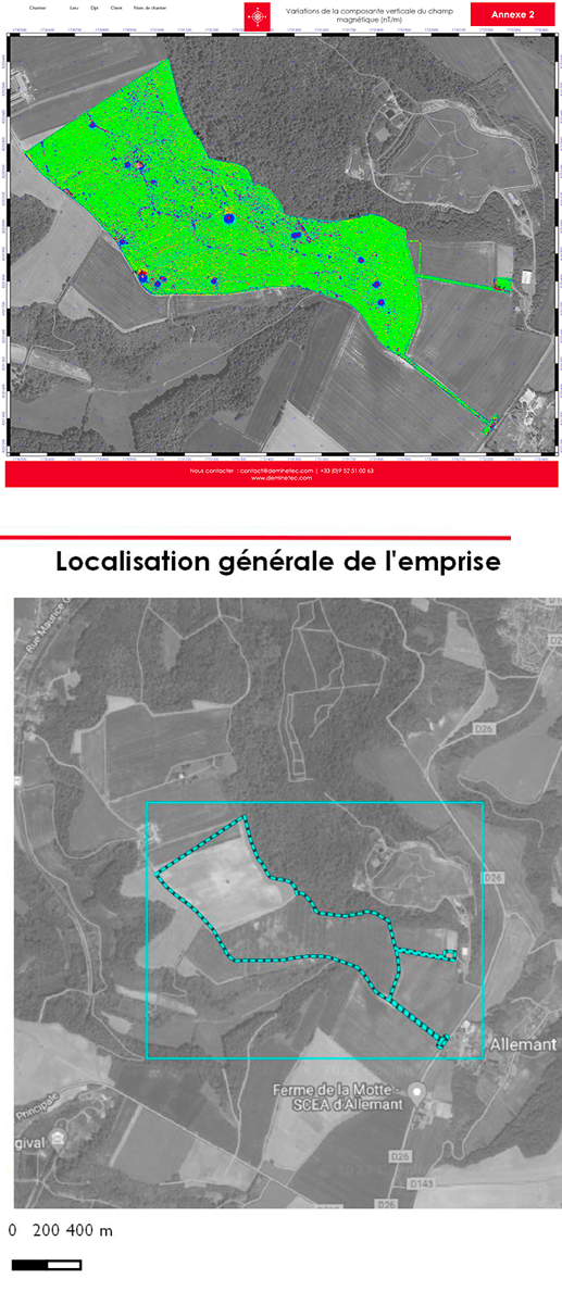
Concerning magnetometry, the principle is to measure the terrestrial magnetic field and identify the ferrous anomalies during this measurement (iron wire, metal jug/can, IPN, munitions, etc.) that cause disturbance. Data analysis is performed using a software interface that represents the investigated zone “plan view” on which the anomalies can quickly be identified (traditionally shown in red and blue).
Concerning electromagnetism, there are 2 sub-processes:
To reinforce our knowledge and abilities, DEMINETEC has enlisted the collaboration of the UXOMAP company for its explosive contamination diagnostic operations. Visit their website at www.uxomap.fr
These geophysical methods can also allow our geophysicists to respond to other more traditional concerns such as:
Results according to technological limits.
Guarantees and limits.The material means used during explosive contamination diagnosis are geophysical tools whose main purpose has been modified to identify any anomalies present in the subsoil that may be unexploded ordnances or explosive remnants of war. They are not munitions detectors.
As such, these detectors are subject to the various limits of these methodologies. It is therefore difficult to define the exact size of an object (or its weight or volume), or its depth, with any certainty.
Magnetometry:
Magnetometry is highly sensitive to all surface effects, notably all types of ferromagnetic superstructures (buildings, fences, machinery, cars, etc.). The presence of these types of objects on the surface does not allow for measurement within several meters of these objects. The more the terrain is polluted by ferromagnetic objects, the more difficult the individualization of the anomalies and the more the technical characteristics and depth of the object are complex to identify.
The display scales of cartographies or data processing thresholds are essential for defining the munitions typologies to be identified according to their depths. In general, the smaller a munition, the less detectable it is at depth.
Fluxgate magnetometry can be used to identify a bomb of 250 to 500 kg at maximum depth of up to 3 or 4 m in optimal surface and terrain conditions.
Total field magnetometry can be used to investigate the subsoil at slightly greater depth (about 30% more), but at the same time, it is more greatly influenced by superstructures. According to the means used (mono or multi-antenna, georeferenced in real time or post-processing) and terrains to be investigated (flat or rocky, cleared or not, structures present or not, accessible on foot or by vehicle, large or small), the magnetometric diagnostic may cover between 2500 m² and 10 hectares per team and per day, or even more for aerial means.
Electromagnetism (TDEM):
TDEMs intended to search for unexploded munitions have search depths between 2 and 3 m maximum for the largest objects. They remain influenced by superstructures, but in lesser proportions than for magnetometry.
Classification of anomalies by category and depth underground are more precise due to the various windows of measurement as compared to magnetometry. Similar to magnetometry, the display scales of cartographies or data processing thresholds are essential for defining the munitions typologies to be identified according to their depths.
Within the same constraints as for magnetometry, the TDEM diagnostic can cover between 2500 m² and 2 hectares per team, per day. It should be noted that this method enables detection of ferrous and non-ferrous objects. This method is therefore mandatory for diagnostics of modern shooting ranges where magnetometric measurements would not work.
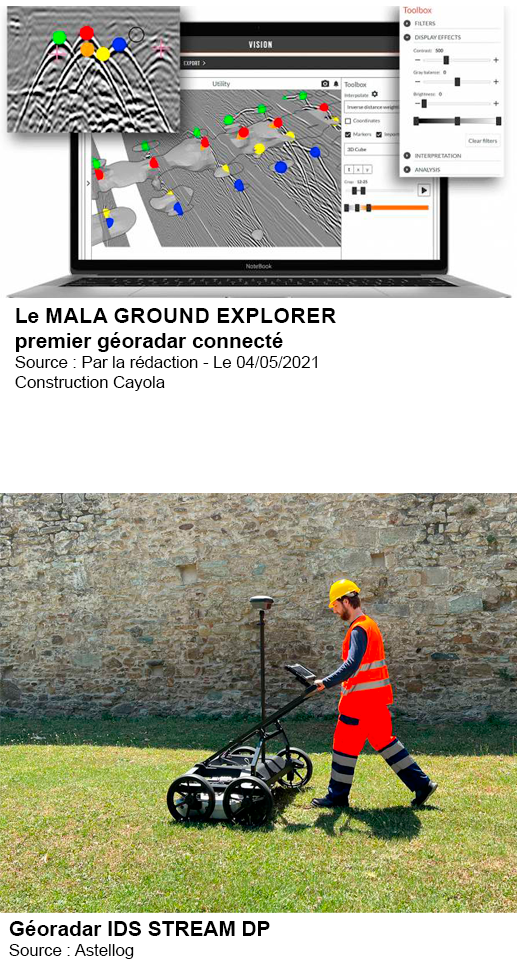
Electromagnetism (GPR):
GPR measures dielectric change zones. This means it is extremely restricted by the consistency of the subsoil and therefore by the various layers comprising it. The presence of a zone of backfill or water in the surface layers does not allow for deeper investigations.
GPR does not make a clear distinction between a ferrous, non-ferrous or geological anomaly. However, compared to the other methods, it allows investigation of areas near to superstructures using its shielded antennae. The choice of shielded antennae is essential, as a matter of fact, because they allow for investigation at greater or lesser depth with more or less precision of the subsoil.
Within the same constraints as for magnetometry and TDEM, GPR diagnostics can cover between 2500 m² and 5000 m² per team, per day.
Characterizations.
First, we must remember that it is impossible to distinguish between a munition and an inert object of a basically identical shape.Depending on the principle used, it is also possible for a shell and barbed wire to have the same “signature”, notably in magnetometry.
Use of devices and data processing must be entrusted to personnel specialized in this field (explosive diagnostics) and who have the operating experience necessary for incrementation of data according to the objects discovered. DEMINETEC employs geophysicists who have been specialized in searching for munitions for many years and who have extensive operating experience in processing and discovering potential targets. This experience allows us to ensure our customers get the best quality services and guarantees detection and decontamination of their sites within the technical limits of the detection devices.
Software characterization
DEMINETEC has several software programs for processing magnetometric or electromagnetic data. These programs (mainly developed by the manufacturers of detection equipment) are basically identical and provide a number of indications related to the geometry and depth of the objects.
This information is to be considered with the utmost caution and is only an indication as it is mainly dependent on the environment of the object detected.
Multi-method characterization
Concerning the largest objects (aerial bombs, notably), DEMINETEC is capable of ensuring complementary characterization by 3D GPR. This method allows us to more finely characterize a ferromagnetic object present in the subsoil through almost immediate feedback on its shape, with much more precision.
This method requires the operator to be rather close to the target being characterized (about 1 m) in order to use antennae of sufficient resolution to characterize this type of object. Considering the strict outside constraints related to discovery of a target such as an aerial bomb, this method is very much recommended.
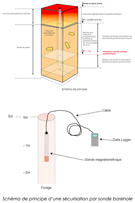
Securing surveys and detection at great depth.
As part of its geophysical and explosive diagnostics, DEMINETEC is able to ensure services to secure surveys with respect to various risks relating to the presence of objects in the subsoil.We are capable of ensuring secure surveys through magnetometric means and/or GPR when it comes to the explosion risk or the presence of networks.
The interaction between the driller and DEMINETEC must be of the best quality to guarantee the safety of operations and the quality of services. As such, we can offer a complete drilling and security service for your operations through our collaboration with partners nationwide.
Also, DEMINETEC has the ability to investigate entire large surface areas through drilling, notably in the case of explosive contamination situated at depths greater than the detection capacity of geophysical devices from the surface.